
|
|
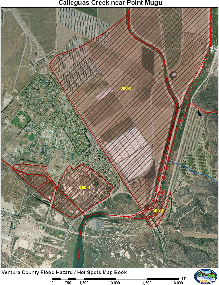
Ventura County
|
GIS Hot Spot ID:
380-3 Highway 1 Bridge over Calleguas Creek
380-4 Point Mugu Drain – Flooding on Base
380-5 Flooding Widespread Flooding Wood Road to Las Posas Road
The main areas of impact are Highway 1 and the Point Mugu Navy Base.
Historical Data
Major flooding occurred along this stretch of Calleguas Creek in 1980 and 1983. The Point Mugu Navy Base was severely impacted in 1980 leading to the installation of the Flood Warning System in Ventura County. Minor flooding at Highway 1 occurred in 1998 and 2005. See table in previous section for historical flows.
Historical Data
Major flooding occurred along this stretch of Calleguas Creek in 1980 and 1983.
|
Date |
Flow at 805 |
Areas Affected |
|
2/16/1980 |
25,300 cfs |
Multiple failures of levees along Calleguas Creek flooded agricultural fields between Calleguas Creek and Revolon Slough. Successive failure of levees along Revolon caused major damage at Point Mugu Naval Base. |
|
3/1/1983 |
25,900 cfs |
Multiple failures of levees along Calleguas Creek flooded agricultural fields between Calleguas Creek and Revolon Slough. Flooded agricultural fields lead to the failure of the Revolon Slough levee at Las Posas Road. Agricultural fields next to Camarillo State Hospital (now CSUCI) were also flooded. Major damage to Lewis Road due to breakouts. |
|
2/6/1998 |
21,600 cfs |
Flooding of Highway 1 bridge, some flooding of base housing at Point Mugu. |
|
1/9/2005 |
19,700 cfs |
Flooding of Highway 1 bridge. Some erosion of levees along Calleguas Creek above CSUCI. Some flooding of base housing at Point Mugu. |
Aerial Photo and Map
Photos of Area
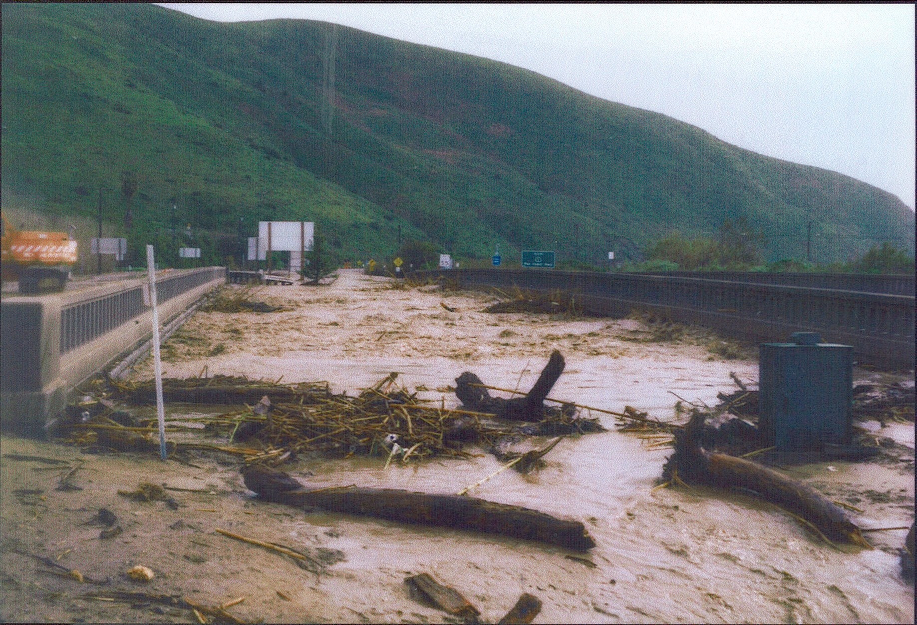
Calleguas Creek at Highway 1, February 1998, VCWPD
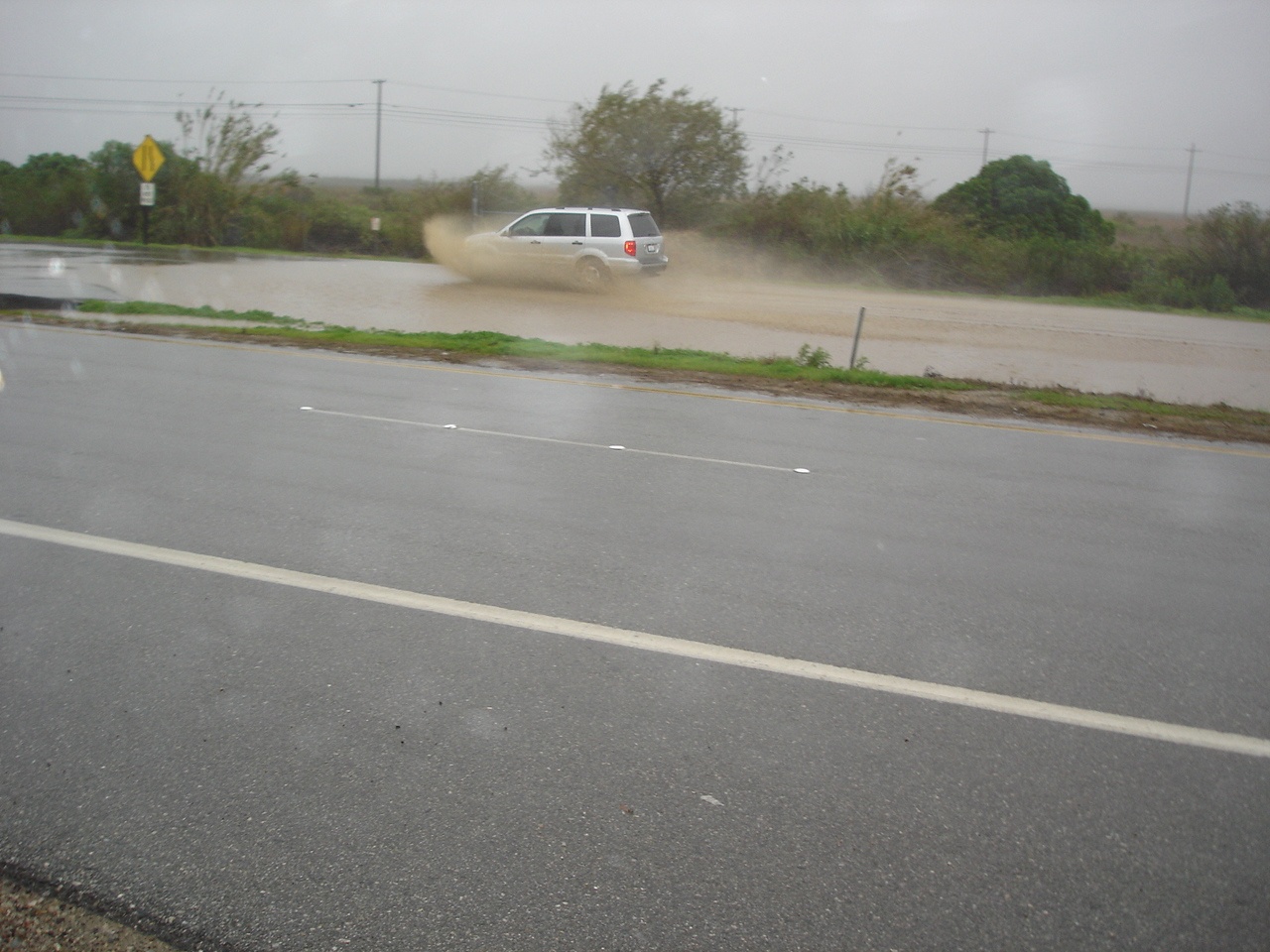
Calleguas Creek at Highway 1, January 2005, NWS photo
Gages
The main stream gage Calleguas Creek at CSUCI (805) is located at the University Drive Bridge. This gage transmits both on ALERT and GOES. Alternate stream gages are located upstream above the confluence of Calleguas Creek and Conejo Creek. These gages are Calleguas Creek at Highway 101 (806a) and Conejo Creek above Highway 101 (800).
Special Conditions/ Issues
Navy Base Ventura County – Point Mugu need time to install flood wall for significant flooding.
Minimal Time for Implementation
12 hours to for installation of flood wall around Point Mugu.
2-3 hours for CHP to close Highway 1.
Normal Conditions Procedure
Gages Used: 805
|
Criteria |
Value |
Issue |
Area |
Procedure |
|
Flow |
12,000 cfs |
Mugu Drain Tiadal Gage, Point Mugu Base |
380-4 |
Backwater from Mugu Lagoon may flood the Point Mugu Navy Base. Base Personnel need to be notified that they may have to close the gate. |
|
Flow |
13,000 cfs |
Mugu Drain Tiadal Gage, Point Mugu Base |
380-4 |
Backwater from Mugu Lagoon may flood the Point Mugu Navy Base. Base Personnel need to be notified that they may have to close the gate. |
|
Flow |
15,000 cfs |
Mugu Drain Tiadal Gage, Point Mugu Base |
380-4 |
Backwater from Mugu Lagoon probably is flooding the Point Mugu Navy Base if tidal gate is not closed. Base Personnel need to be notified that they may have to close the gate. Additional rain may flood parts of the base from Mugu Drain because the water cannot flow to Mugu Lagoon, |
|
Flow |
16,000 cfs |
Highway 1 Bridge / Point Mugu |
380-3 |
Debris may be piling up on the Highway 1 Bridge along Calleguas Creek. CalTrans may need equipment to clean debris. If flow is expected to be near 20,000 cfs. Navy personnel may need to install flood way to prevent flooding on the base. |
|
Flow |
18,000 cfs |
Highway 1 Bridge / Point Mugu |
380-3 |
Debris may be piling up on the Highway 1 Bridge along Calleguas Creek. CalTrans may need equipment to clean debris. Water level may rise to have water flow around the bridge. CHP may need to monitor the highway to determine if it needs to be closed. Navy personnel should be installing the flood wall if flows are expected to be higher. |
|
Flow |
19,500 cfs |
Highway 1 Bridge / Point Mugu |
380-3 |
Highway may be flooded and closed by CHP. CalTrans may need to continue debris removal operations. Flood wall should be installed by this flow. |
|
Flow |
22,000 cfs |
Highway 1 Bridge / Point Mugu |
380-5 |
Flooding from breakout along the Calleguas Creek and Revolon Slough levees may lead to widespread flooding of agricultural fields across from Point Mugu Base. Flows may impact Highway 1 and the highway may need a hard closure. Flooding may advance onto the base if the flood wall is not installed. |
|
Flow |
23,000 cfs |
Point Mugu Gate 2 |
380-5 |
Point Mugu needs to have the flood wall installed at Gate 2 near Las Posas Road for possible flooding past the gage. Coordinate with Navy Base Ventura County (Jim Danza). |
Data Source
Original polygons were drafted from the January 2005 meeting with former County Hydrologist and experts. The polygons were refined from known extent of flooding during the 1983 flood event. Point Mugu and lower Calleguas Creek flooding history provided from Jim Danza, Naval Base Ventura County