
|
|
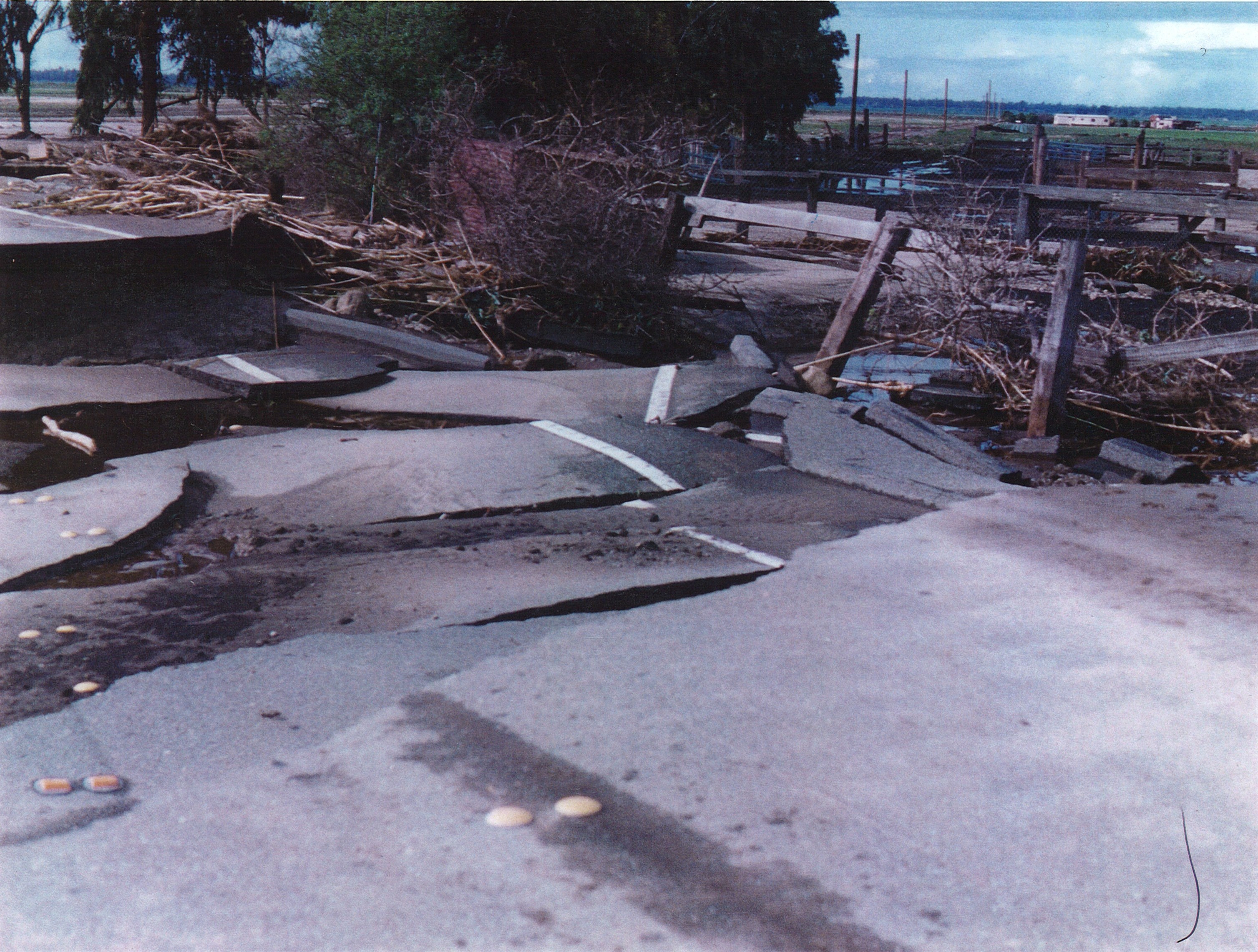
Ventura County
|
GIS Hot Spot ID:
380-1 Breakout below Calleguas Creek, Conejo Creek confluence
380-2 Flooding near CSUCI
380-5 Flooding area between Calleguas Creek and Revolon Slough
The main area of concern is the California State University, Channel Islands (CSUCI). Although flooding of the main campus would be minor, all access roads, and bridges to the campus may be severely damaged isolating the university. Potrero Road to the east is impacted by rockslides and landslides.
Historical Data
Major flooding occurred along this stretch of Calleguas Creek in 1980 and 1983.
|
Date |
Flow at 805 |
Areas Affected |
|
2/16/1980 |
25,300 cfs |
Multiple failures of levees along Calleguas Creek flooded agricultural fields between Calleguas Creek and Revolon Slough. Successive failure of levees along Revolon caused major damage at Point Mugu Naval Base. |
|
3/1/1983 |
25,900 cfs |
Multiple failures of levees along Calleguas Creek flooded agricultural fields between Calleguas Creek and Revolon Slough. Flooded agricultural fields lead to the failure of the Revolon Slough levee at Las Posas Road. Agricultural fields next to Camarillo State Hospital (now CSUCI) were also flooded. Major damage to Lewis Road due to breakouts. |
|
2/6/1998 |
21,600 cfs |
Flooding of Highway 1 bridge, some flooding of base housing at Point Mugu. |
|
1/9/2005 |
19,700 cfs |
Flooding of Highway 1 bridge. Some erosion of levees along Calleguas Creek above CSUCI. Some flooding of base housing at Point Mugu. |
Aerial Photo and Map
Photos of Area
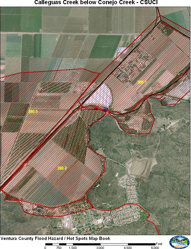
Flooding of agricultural fields west of Calleguas Creek at Lewis Road and
University Drive Bridges, VCWPD 1983.
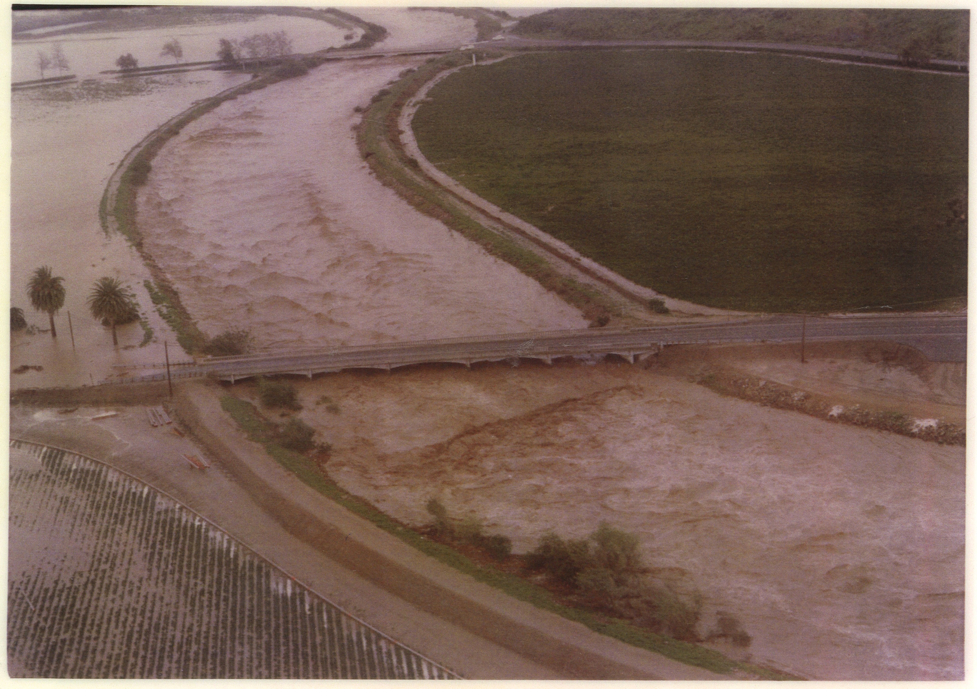
Flooding between Calleguas Creek and Revolon Slough, VCWPD 1983. Breakout
near CSUCI.
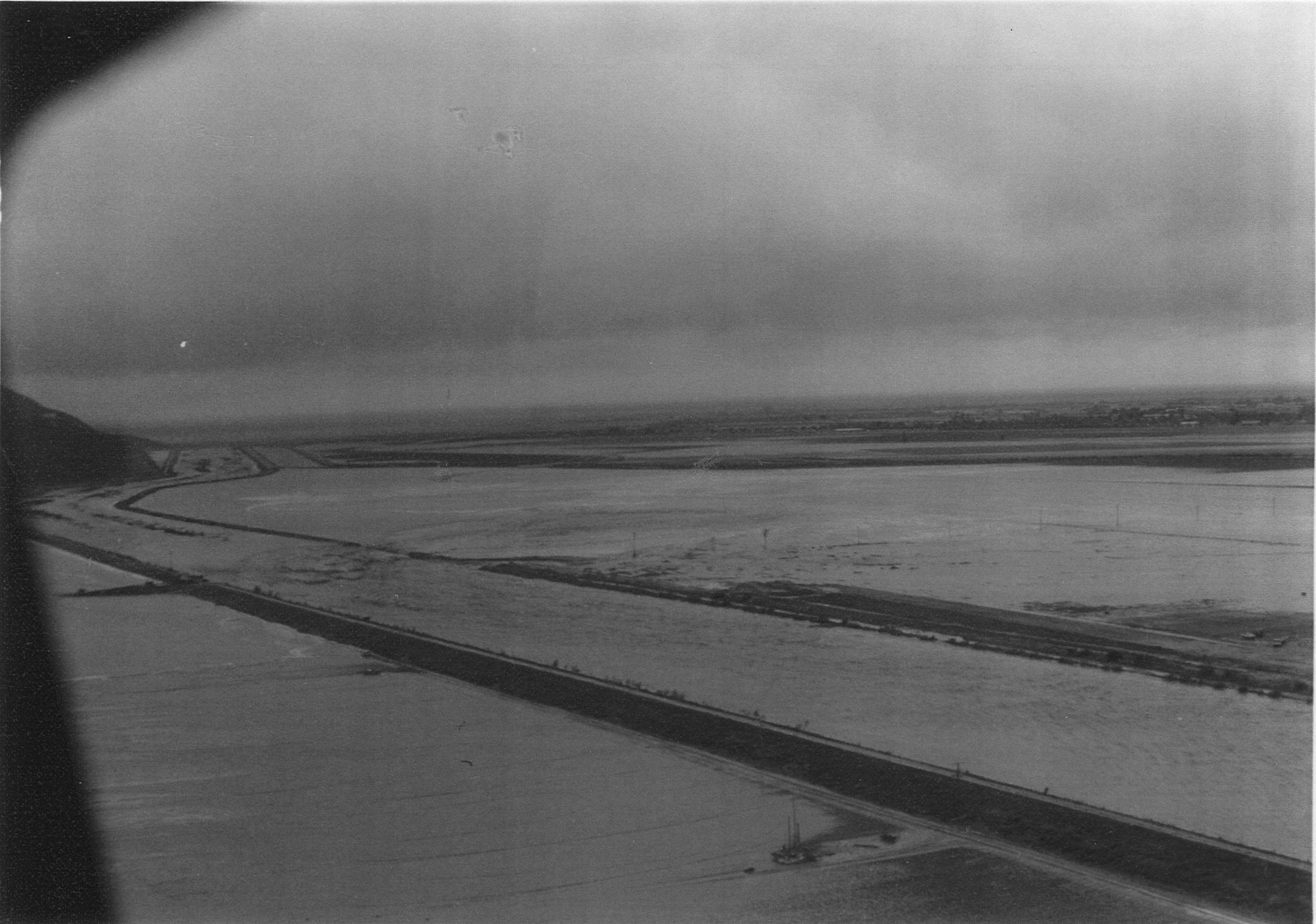
Damage to Lewis Road near Camarillo State Hospital, VCWPD 1983.
Gages
The main stream gage Calleguas Creek at CSUCI (805) is located at the University Drive Bridge. This gage transmits both on ALERT and GOES. Alternate stream gages are located upstream above the confluence of Calleguas Creek and Conejo Creek. These gages are Calleguas Creek at Highway 101 (806a) and Conejo Creek above Highway 101 (800).
Special Conditions/ Issues
CSUCI may become isolated and roads in the area may be damaged.
Minimal Time for Implementation
4-6 hours to for university to implement emergency procedures.
Normal Conditions Procedure
Gages Used: 805
|
Criteria |
Value |
Issue |
Area |
Procedure |
|
Flow |
12,000 cfs |
Agricultural fields below Confluence Calleguas and Conejo Creeks |
380-1 |
Watch flow for the potential of flooding below the confluence of Calleguas and Conejo Creeks. Increase patrols in the area. |
|
Flow |
13,000 cfs |
Agricultural fields below Confluence Calleguas and Conejo Creeks |
380-1 |
Flow approaching capacity below the confluence of Calleguas and Conejo Creeks. Erosion may be occurring along the levees of Calleguas Creek. Have County Roads Department prepare to shut down Lewis Road and consider evacuation of Casa Pacifica. |
|
Flow |
15,000 cfs |
Agricultural fields below Confluence Calleguas and Conejo Creeks |
380-1 |
Breakouts should be occurring along Calleguas Creek below Conejo Creek. Flooding should be limited to areas along the creek but if flows are expected to be higher then flooding can occur to Lewis Road, Casa Pacifica, and Camrosa facilities. Evacuations should be underway if flows are expected to exceed 20,000 cfs at Casa Pacifica. |
|
Flow |
20,000 cfs |
Agricultural fields between Calleguas Creek and Revolon Slough |
380-2, 380-5 |
Watch flow for erosion damage to levees along lower Calleguas Creek below University Drive. Flows approaching levels that could flood land and roads. |
|
Flow |
21,000 cfs |
Agricultural fields between Calleguas Creek and Revolon Slough |
380-2, 380-5 |
Potential exist for failure of levee along Calleguas Creek. Patrols should monitor breakouts. Prepare for closure of Lewis Road, Las Posas Road, and Hueneme Road. Access to CSUCI may be impacted |
|
Flow |
22,000 cfs |
Agricultural fields between Calleguas Creek and Revolon Slough |
380-1, 380-2, 380-5 |
Multiple failures should be occurring along the Calleguas Creek levee. Minor flooding may be impacting the roads at this flow. Higher flows will impact Lewis Road, Las Posas Road, and Hueneme Road. Access to cSUCI is now impacted. |
|
Flow |
23,000 cfs |
Agricultural Fields next to CSUCI |
380-2 |
Watch for potential flooding to agricultural fields next to CSUCI. Flooding on main campus not expected at this flow |
|
Flow |
24,000 cfs |
Agricultural Fields next to CSUCI |
380-2 |
Flooding may be occurring on the agricultural fields next to CSUCI. CSUCI should prepare for possible flooding of lower campus building if flows are expected to be higher. |
|
Flow |
25,000 cfs |
Agricultural Fields next to CSUCI |
380-2 |
Agricultural fields should be flooded and water may be approaching the lower campus buildings. CSUCI personnel should be implementing emergency procedures |
|
Flow |
25,000 cfs |
Agricultural fields between Calleguas Creek and Revolon Slough |
380-5 |
Severe flooding of agricultural fields may lead to failure of levees along Revolon Slough. Potential exists for overland flooding to reach Point Mugu Navy Base. |
Data Source
Original polygons were drafted from the January 2005 meeting with former County Hydrologist and experts. The polygons were refined from known extent of flooding during the 1983 flood event. Point Mugu and lower Calleguas Creek flooding history provided from Jim Danza, Naval Base Ventura County