
|
|
Ventura County
|
GIS Hot Spot ID:
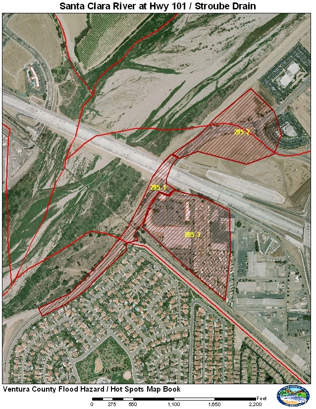
285-1 Ventura Road
285-2 Stroube Drain and Stoplogs
285-3 Wagonwheel Shopping Center and Mobile Home Park
The area around the Santa Clara River and Highway 101 Bridge has three “Hot Spot” areas. The levee that protects the El Rio area stops at the Highway 101 Bridge. Ventura Road also dips under the Union Pacific Railroad Bridge. These two issues leave Ventura Road susceptible to flooding. Any rain storm can create flooding at undercrossing but it is only when there are high flows in the Santa Clara River where the water depth can become dangerous and entire vehicles can be submerged. If water levels continue to rise water can flow from Ventura Road into the adjacent shopping center and the mobile home park just to the east.
The final area is the Stroube Drain located on the north side of the Highway 101 Bridge. Stroube Drain is designed to use stoplogs to prevent high flows from the Santa Clara River from flooding the Riverpark area. If the stoplogs are installed too early, water from Stroube will backup and flood the Riverpark area. Patrols will need to monitor the situation around the time of the peak flow to determine if the stoplogs need to be inserted.
Historical Data
January 10, 2005 produced a peak of 136,000 cfs. Ventura Road was reported to be under water and it was closed. Stroube Drain continued to function but the flow direction was close to reversing. The stoplogs were not installed during this event. Also during this event the Highway 101 Bridge was under construction and sustained major damage to the section under construction. The Union Pacific Railroad sustained some damage along the bank on the Montalvo side. The largest flow recorded on the Santa Clara River was in 1969 at 165,000 cfs. This record flow occurred before any improvements or development in these “Hot Spots”
Aerial Photo and Map
Photos of Area
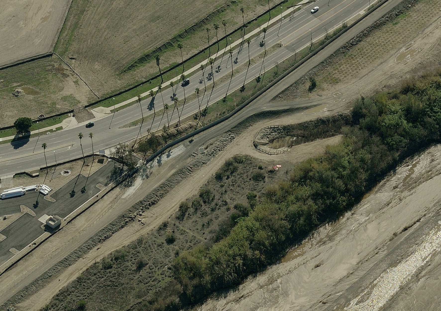
Stroube Drain
Outlet and Stoplog Access on levee, Pictometry 2008 photo
Gages
There are currently two gage sites that measure flows along the Lower Santa Clara River. One is upstream at the Freeman Diversion and the other is downstream at Victoria Ave. The gage at Freeman has two sensors. The bubbler (724) provides the best recording but is heavily influenced by drawdown by the main gate. The second sensor is a sonic (A639) place on the weir. The rating at Freeman should be good for flows between 30,000 cfs and 150,000 cfs. The official gage for the Santa Clara River is located downstream at Victoria Ave. This gage will have updated rating for low and moderate flows. To verify flows, the stream gage at Sespe Creek at Grand (710) can be used to estimate flows. The general rule of thumb is Sespe provides about 60% of the total flow for the Santa Clara Rvier.
There was a gage previously installed at the Highway 101 Bridge but it was removed in 2004 for construction of the new bridge. Official record started at the Highway 101 Bridge (707) but moved to other locations including Saticoy (707A), Freeman Diversion (724), 12th Street Bridge (720), and Victoria Ave Bridge (723).
Special Conditions/ Issues
Ventura Road is monitored by the City of Oxnard and the city pre-stages barricades and signs for closures. The higher flows causes additional damage that can cause long term closures and isolate the Wagon Wheel area. Higher flows also have the potential to start flowing into the shopping center. Only the extremely highest flows should impact the shopping center and mobile home park. Both sites are currently planed for redevelopment in the future.
The stoplogs on Stroube Drain are a manual device to prevent high flows from the Santa Clara River from flooding the Riverpark area. A problem occurs because when the stoplogs are in place, Stroube cannot drain and water backs up and starts to flood the lower areas of Riverpark. Stroube will need to be watched during high flows on the Santa Clara River to make sure that the stoplogs are in place when the flows would reverse direction when the peak flow occurs on the Santa Clara River. The stoplogs will need to be removed as soon as possible so Stroube Drain can resume its job to drain Riverpark to the Santa Clara River.
Minimal Time for Implementation
Closure of Ventura Road: 30 minutes
Installation of Stoplogs: 3 hours setup, 30 minutes implementation?
Evacuation of Wagon Wheel: 4 hours
Normal Conditions Procedure
Gages Used: 723, 724
|
Criteria |
Value |
Issue |
Area |
Procedure |
|
Flow |
35,000 cfs |
Ventura Road |
285-1 |
Prepare for long term closure of Ventura Road. Pass information to OES |
|
Flow |
45,000 cfs |
Ventura Road |
285-1 |
Ventura Road should be closed if it has not already from local flooding. |
|
Flow |
50,000 cfs |
Ventura Road |
285-1 |
Ventura Road should be under enough water that even large vechicles are unable to use the road. |
|
Flow |
70,000 cfs |
Stroube Drain |
Stoplogs |
Prepare for implementation of stoplogs if flows are expected higher than 70,000. O&M need to prepare staffing to monitor Stroube Drain for forecasted peak period. |
|
Flow |
90,000 |
Stroube Drain |
285-2, stoplogs |
O&M should have regulare patrols to monitor the direction of the flow in Stroube Drain. If the flow starts to reverse, the stoplongs need to be inserted. |
|
Flow |
120,000 |
Stroube Drain |
285-2 |
Flow should be reversing and Riverpark will start to flood if the stoplogs are not inserted. |
|
Flow |
120,000 |
Wagon Wheel Area |
285-3 |
Prepare for possible evacuations of the shopping center and mobile home park if flows are expected to rise above this flow. Flows at this level may cause flooding under Hwy 101 and at the Wagon Wheel Raod and Ventura Road intersection causing access issues. Coordinate with OES. |
|
Flow |
135,000 |
Wagon Wheel Area |
285-3 |
Shopping Center should be evacuated and mobile home park should start evacuation procedures at this flow, especially if the peak has not arrived yet. Coordinate with OES |
|
Flow |
150,000 |
Wagon Road Area |
285-3 |
The shopping center should have flooding and water should be approaching the mobile home park. Evacuations should have occurred by this time. |
Data Source
Most numbers for the criteria have been made from observations or estimates from Hydrologists and Engineers. Attempts should be made to use model results to tighten the thresholds for Ventura Road and the Wagon Wheel area.