
|
|
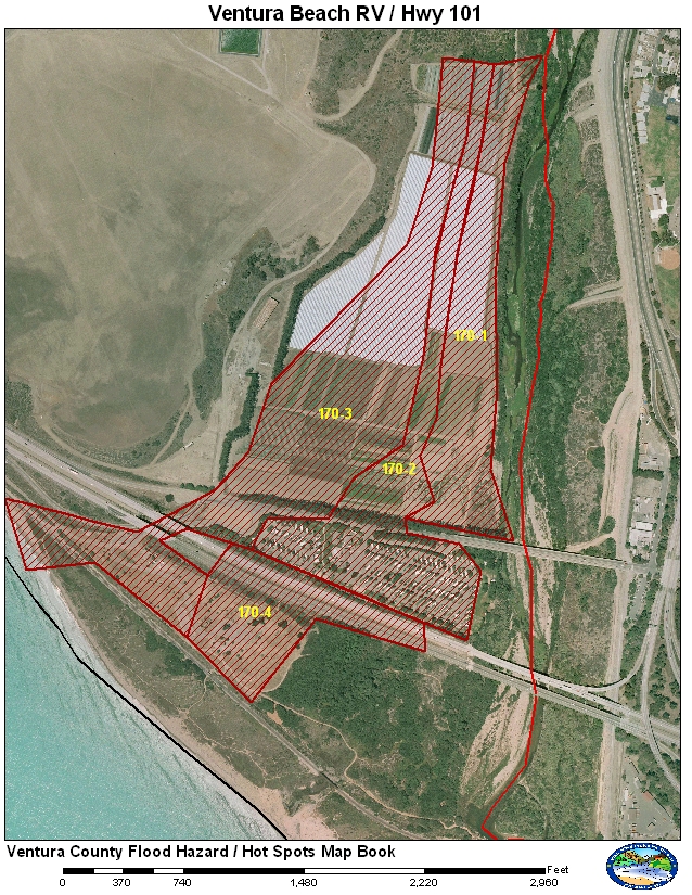
Ventura County
|
GIS Hot Spot ID:
160-1 Agricultural Fields (Welty Property)
160-2 Ventura Beach RV Park
160-3 Main Street, Emma Wood State Beach
160-4 Highway 101, Emma Wood State Beach
The lower end of the Ventura River is usually the first area that has issues with flooding. The Ventura Beach RV Park was built in the floodway. This area of the river is actually a delta and the Ventura River had historically split into tributaries. Old railroad maps show a West Fork and East Fork. Currently the Ventura Beach RV Park and part of Highway 101 act as a barrier to the old “West Fork.” Highway 101 also dips down and acts as an “Arizona Crossing” during high flows. A berm separates the highway from the RV Park.
Historical Data
The first flooding issues after the RV Park was built occurred in February 1992 which resulted in over $1 million in damage at the Ventura Beach RV Park alone. The damage was due to property damage and damage to RVs that were not or could not be moved. At least one RV was taped by a news crew being swept back into the Ventura River and being destroyed when the RV collided with the Highway 101 bridge. The RV Park was also flooded in 1995, 1998, and 2005. The water overtopped the berm between the RV Park and the highway in 1992, 1995, and 2005. The table below shows the peaks that occurred and flooding that occurred.
|
Date |
Flow at 608 |
Areas Affected |
|
2/12/1992 |
45,800 cfs |
Damage to RV Park, water damaged structures at Emma Wood State Beach and water flooded over Highway 101 between the bridge and the Main Street undercrossing. |
|
1/10/1995 |
43,700 cfs |
Damage again to the RV Park, Emma Wood State Beach and water flooded Highway 101. Damage was also reported at the railroad bridge just downstream of Highway 101. |
|
2/23/1998 |
38,800 cfs |
Damage again to the RV park but only minor flooding to Emma Wood State Beach. Water did not flood Highway 101. The Main Street and the Union Pacific Railroad bridges were damaged during the storm. |
|
12/31/2004 |
20,600 cfs |
Some flooding north of Main Street on the Welty property. At the peak some flow came across the agricultural fields and flowed under a drainage bridge and into the RV Park. It left some mud in the RV Park but caused no major damage. |
|
1/9/2005 |
29,400 cfs |
Flooded the agricultural fields and the RV Park. Flows did not go over Main Street. Highway 101 was not affected. |
|
1/10/2005 |
41,000 cfs |
Flooding at RV Park, Emma Wood State Beach and Highway 101. Highway101 was closed for several hours. |
Aerial Photo and Map
Photos of Area
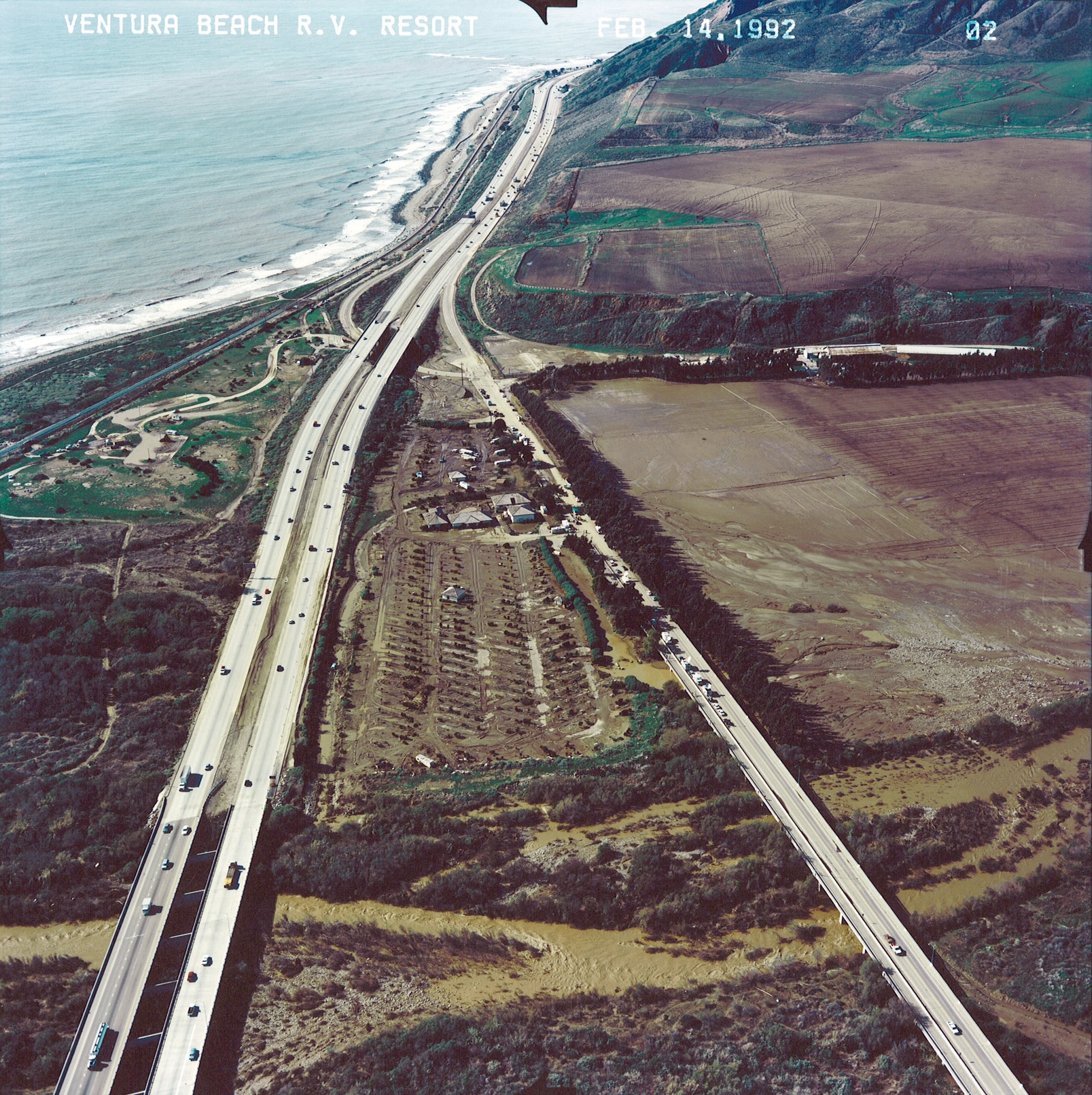
Aerial image show damage to RV Park, Highway 101, and State Park areas from Feb.
1992 storm.

NWS photo showing damage to SPRR bridge after Feb 1998 storm.
Gages
The main gages used for monitoring the lower Ventura River are the stream gages at Foster Park. There are two separate systems. One instrument is a non-contact radar operated by the USGS. The other is a float gage that is maintained by VCWPD. The float is set up to work as a backup to the main radar system. For this reason, the rating for the float does not become accurate until there are at least 3,000 cfs in the river. The float may measure some partial low flows which could be flows from Coyote Creek or braiding in the main channel but the flow values are not accurate. If the gages at Foster Park fail, the next closest gages are at San Antonio (605) and an ALERT sonic on the Ventura River at Santa Ana Blvd (612). The rating at Santa Ana Blvd is poor because there are no rating measurements made at this site. The rating is theoretical but should provide a good estimate at higher flows. Verify with flows from Matilija Dam and North Fork Matilija.
The RV Park usually floods before the Emergency Operations Center (EOC) becomes active. Since the EOC is not open, coordination must be made with the Sheriff’s Office of Emergency Services (OES), and the City of Ventura Police and Fire Departments.
Evacuate and secure Ventura Beach RV Park: 3 hours (more if possible)
Evacuate and secure Emma Wood State Beach: 3 hours (more if possible)
CHP to close Highway 101: 30 minutes (prefer at least 1 hour or more)
The response time between the Foster Park stream gage and the Ventura Beach RV Park is just over 1 hour. For higher flows this means that the Hydrologist will need to depend on the model using the observed stream flow to see how the model is progressing early in the event. For the threshold to evacuate the RV Park, this can be an observed value and is not dependent on any forecast model.
Gages Used: 608
|
Criteria |
Value |
Issue |
Area |
Procedure |
|
Flow |
13,500 cfs |
RV Park |
170-2 |
City of Ventura starts the evacuation of the RV Park as a precaution. Coordinate with the City and OES. The city will start the evacuation once the flow at the Foster Park Stream Gage has reached 15,000 cfs and is not dependent on any forecast model. |
|
Flow |
17,000 cfs |
Agricultural Fields |
170-1 |
Water starts to encroach on the agricultural fields just north of the RV Park. |
|
Flow |
18,000 cfs |
RV Park |
170-1, 170-2 |
Agricultural Fields start to flood. RV Park should be evacuated by this time. |
|
Flow |
20,000 cfs |
RV Park |
170-1, 170-2 Prep 170-3, 170-4 |
Ventura River has flooded the lower agricultural fields and is now flowing into the RV park via agricultural drainage channel that goes under Main Street and into the RV Park. State Parks should consider evacuating Emma Wood State Beach. |
|
Flow |
25,000 cfs |
Main Street & Emma Wood |
170-2, prep 170-3, 170-4 |
Water surface elevation approaches Main Street. Ventura City and CHP should have patrols and consider shutting down Main Street at Hwy 33 and Hwy 101. Emma Wood State Beach should be evacuated by this point. Coordinate through OES. |
|
Flow |
30,000 cfs |
Main Street & Emma Wood Highway 101 |
170-3, 170-4 |
Water surface elevation should be impacting Main Street. Water along Main Street and from the RV Park begins to flow under Highway 101 at the Main Street off-ramp and into Emma Wood State Beach. CHP should be notified that Highway 101 may be impacted. Coordinate through OES. |
|
Flow |
40,000 cfs |
Highway 101 |
170-3, 170-4 |
Water flows over the berm between the RV Park and Highway 101. CHP will need to shut down the highway. Emma Wood State Beach in inundated. Flows may start to impact the railroad due to erosion. |
Threshold values were created using observed values from the Ventura River at Foster Park USGS stream gage. These values do not take in consideration the flows from the watersheds downstream such as Canada Larga.